Fact Sheet #1
A Guide to the Conceptual Site Model (CSM) and Contaminants of Concern (COCs) in Newtown Creek and the East River
Background Information
Superfund is a US Environmental Protection Agency (EPA) program that evaluates potential risks from waste sites, contaminated waterways, and other sites. The Superfund program also develops remedies at these sites to reduce risks to human health and the environment. The EPA oversees, reviews, and approves all work conducted under the Superfund program.
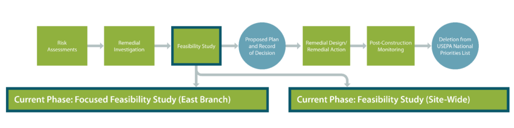
The Remedial Investigation (RI) phase of the Superfund process in Newtown Creek was completed on April 7, 2023. A public copy is available on the NCG Website. The Feasibility Study (FS) phase is in progress. The FS uses data collected and scientific models built during the RI to evaluate remedial alternatives for the creek using nine criteria. Additional data collection is often needed to support development and evaluation of remedial alternatives. A Focused Feasibility Study (FFS) is currently being conducted on the East Branch segment of Newtown Creek. It will evaluate potential cleanup alternatives for this area of the creek and will be implemented on an expedited timeline which will begin cleanup activities sooner and inform cleanup options for the rest of the creek. The FS process for the rest of the creek is continuing in parallel with the FFS process for East Branch.
Conceptual Site Model of Newtown Creek
A conceptual site model (CSM) is a way to compile all the RI information and link it together in a way that provides a comprehensive understanding of the Superfund Site and assists in the development of appropriate remedial options for the Site. Below is a figure illustrating the CSM for Newtown Creek.
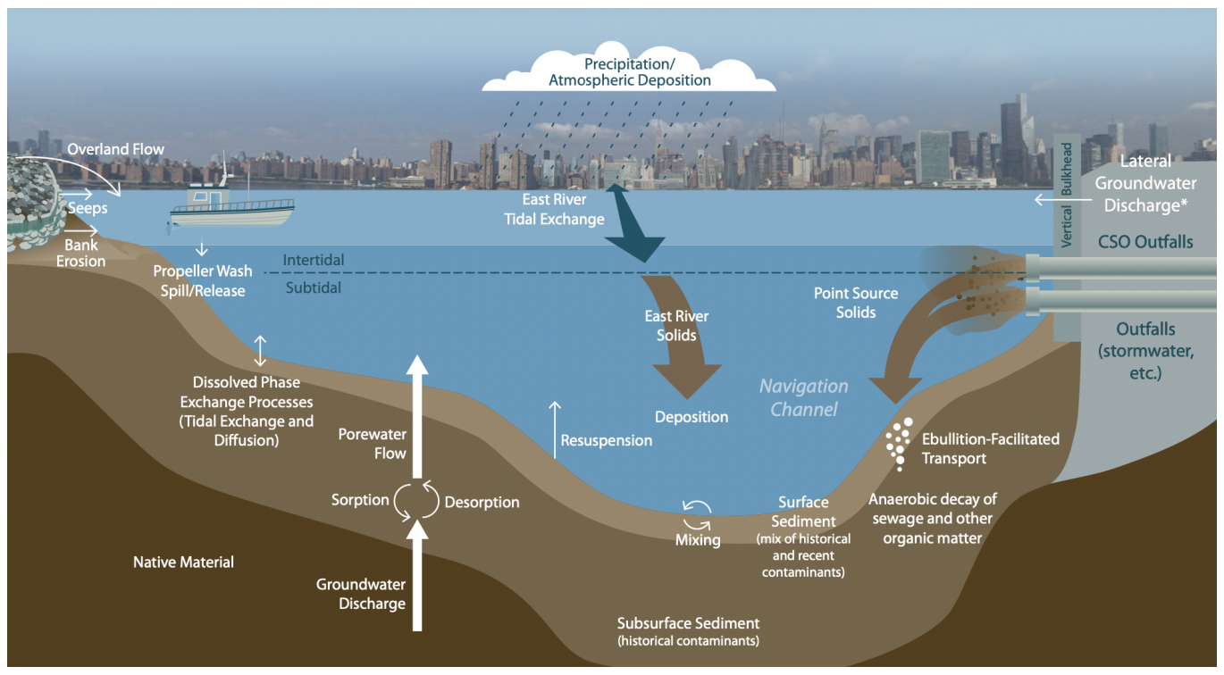
The CSM figure shows the primary sources of water and contaminants going into the creek, and how these sources interact with the existing contaminants found in the sediment at the bottom of the creek. The primary sources of water and contaminants going into Newtown Creek are the East River, and sewer and storm drain discharges.
The contaminants of concern (COCs) are the chief contaminants, identified by the EPA through the human health and ecological risk assessment process, that pose unacceptable levels of risk to human health and the environment that the remedy will have to resolve. COCs are introduced into the creek through the various sources shown on the CSM figure above. The risk assessments have identified the following COCs in Newtown Creek: polychlorinated biphenyls (PCBs), polycyclic aromatic hydrocarbons (PAHs), petroleum hydrocarbons (C19 to C36), metals, and dioxins/furans.
COCs found in the sediment at the bottom of the creek are due in part to Newtown Creek’s centuries-long past and current uses as an industrial and municipal waterway. COCs in Newtown Creek can also enter the creek in combined sewer overflows (CSO)- a combination of sewer wastewater and street drain stormwater which, during moderate and heavy rain events, flow into the creek untreated, bypassing wastewater treatment plants. In addition to these combined sewer overflows, other COCs enter the creek in stormwater runoff from adjacent properties, spillage from industrial vessels navigating the creek, and COCs on suspended solids in the water that travel from the East River into Newtown Creek during the natural process of tidal exchange and settle to the bottom. COCs in Newtown Creek exist as a result of past and current industrial sources. Because of the daily occurrence of tidal exchange between the East River and Newtown Creek, the East River will continue to be an ongoing source of chemical contamination for the sediment beds of Newtown Creek. Additionally, municipal pipes will continue to carry COCs into the creek from sewer and stormwater outfalls.
The RI data used to develop the CSM shows that the East River is the predominant source of solids and COCs in the surface layer of sediment in the lower two creek miles. The concentration of COCs measured in surface sediment in the first two miles from the creek’s mouth are lower than the upstream areas of Newtown Creek; the amount of COCs in the downstream areas of the creek are at or below levels that could be a risk to human health or the environment. This stands in contrast to COC concentrations in the upstream part of the creek and the creek’s tributaries, which are higher and present potential risk to human health and the environment. RI data shows that the surface layer of sediment in the creek’s tributaries is heavily influenced by combined sewer overflows and stormwater runoff from City pipes that empty into these areas of the creek.
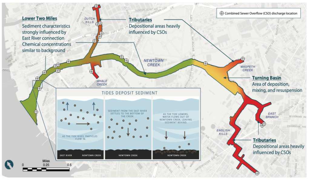
East Branch
The figure below shows the predicted contribution from local sources to the total solids deposited onto Newtown Creek’s sediment bed. The surface sediment in the tributaries of the creek is expected to have the highest total deposition due to shallower depths and lower circulation than in the main stem of the creek. One of these tributaries, the East Branch, is an ideal site for an early action to test remedy efficacy against the various sources of contamination. In addition to the influence of discharges, the East Branch provides a good test case because it includes high concentrations of COCs.
Collecting Supplemental FS Data
For some COCs, more comprehensive data collection is needed to understand the extent of their impact and volume in the creek’s surface sediments as well as how much of these COCs are entering the creek from the East River and from other sources.
The RI sampling completed in 2012, 2014, and 2018 provide the basis for understanding the nature and extent of these particular COCs. Additional data collection will occur in the first to miles of the Creek to better understand their presence. This includes the collection of hundreds of samples of surface water and sediment COCs entering the creek from the East River for further evaluation of COC concentrations changes over time, including projections of these concentrations after remedy implementation. Supplemental data collection programs will take place in 2023 and 2024 to further measure COCs and assist with the development of remedial options proposed in the FS.
Additionally, the City of New York will also collect surface water and sediment COC data in 2023 to measure concentrations of COCs originating from sewers and stormwater runoff. The City will use data collected from the discharge pipes carrying COCs to understand whether additional controls for COCs originating from sewer and stormwater overflows are needed, in accordance with their Long Term Control Plan.